Monday, November 21, 2011

Question #6 Water Cycle

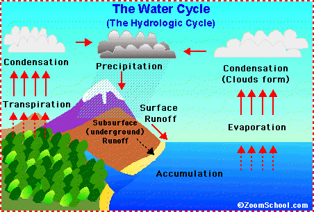
The water cycle includes several processes, all of which keep it continually flowing.  These processes are known as evaporation, transpiration, condensation, and precipitation.  Also included are Infiltration, surface runoff, groundwater, and absorption.

Most everyone has learned about the tradition water cycle.  There’s evaporation, which is simply the process by which a liquid becomes a gas, (1 and 9) transpiration, which is the same thing as evaporation except that the water vapor is being released from pores in the leaves of plants, (2 and 9) condensation, the cooling of water in the air so it reverts to its liquid state, (3 and 9) and, finally, there is precipitation, where the water falls back to earth in the familiar forms of rain, snow, sleet, and hail. (4 and 9)

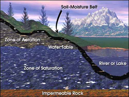
What most people miss is that there’s more to it than that.  For instance, once the water falls as rain, where does it go?  Sure, it eventually gets back into the oceans, but not all water falls over streams and rivers, so where does the water that falls over land go?  Most of it flows over the land as surface runoff which eventually flows into the streams and rivers.  Surface runoff is water that just flows overtop of the soil, like the little rivulets of water you see going down the sides of your road when it rains. (6 and 9)  It just keeps flowing until it either is absorbed into the ground (5 and 8) or makes its way into a stream or river.  But that begs the question, what happens to the water that is absorbed into the ground?  Most of it stays in the upper layers of soil (5) and will eventually be picked up by plant roots, make its way horizontally into a streambed, or evaporate as the ground dries.  Some however will penetrate further into the ground and reach aquifers, becoming part of the ground water that we drink and use every day. (7)

Everyone is aware of the fact that rivers and streams swell when it rains.  Just as most people know that creeks flow into streams, which flow into rivers, which flow into still larger rivers, which eventually empty into lakes or oceans.  Some rivers, such as the Nile River in Egypt, flood annually due to heavy precipitation.  While the Nile no longer does, courtesy of a dam built to control such things, the fact remains that without it, the heavy summer rains further upstream would cause the river to burst its banks. (10)  Rivers are affected by the surface runoff.  This runoff is heated by roads and parking lots, and it picks up a lot of sediments from the land it flows over.  When it is deposited into the river it can have serious effects on the water quality of the river. (6)  Land use decisions can reduced the amount of surface runoff and keep unnecessary sediments from the rivers.


1.       http://ga.water.usgs.gov/edu/watercycleevaporation.html; Last modified February 08, 2011; USGS; Page Contact Information: Howard Perlman
2.       http://ga.water.usgs.gov/edu/watercycletranspiration.html; Last modified July 1, 2011; USGS; Page Contact Information: Howard Perlman
3.       http://ga.water.usgs.gov/edu/watercyclecondensation.html; Last modified November 18, 2011; USGS; Page Contact Information: Howard Perlman
4.       http://ga.water.usgs.gov/edu/watercycleprecipitation.html; Last modified February 08, 2011; USGS; Page Contact Information: Howard Perlman
5.       http://ga.water.usgs.gov/edu/watercycleinfiltration.html; Last modified February 08, 2011; USGS; Page Contact Information: Howard Perlman
6.       http://ga.water.usgs.gov/edu/watercyclerunoff.html; Last modified February 08, 2011; USGS; Page Contact Information: Howard Perlman
7.       http://ga.water.usgs.gov/edu/earthgw.html; Last modified February 08, 2011; USGS; Page Contact Information: Howard Perlman
8.       http://water.usgs.gov/wsc/glossary.html; Last modified February 10, 211; USGS; U.S. Department of the Interior and U.S. Geological Survey
9.       http://www.nwrfc.noaa.gov/info/water_cycle/hydrology.cgi; Northwest River Forecast Center; NOAA; National Oceanic and Atmospheric Administration
10. http://www.touregypt.net/featurestories/nile.htm; ©1996-2011 Tour Egypt.  All Rights Reserved; Web development: AKNsolutions.com

Question #4 Plate Tectonics Theory

Plate tectonics account for several features found on our Earth, including mountains, volcanoes, subduction zones, and mid ocean ridges.  They also account for several processes and occurrences such as seafloor spreading and earthquakes.  Almost all of these occur at plate boundaries, with a few notable exceptions among volcanoes and earthquakes, though there are more exceptions of the former than of the latter.
Seafloor spreading occurs at divergent plate boundaries between oceanic plates, which are also where mid-ocean ridges form.  Mid-ocean ridges are ridges of volcanoes extending all along the boundary between the plates.(1and 2)  As the two plate move apart, hot magma from the mantle rises through the crack, cools, and solidifies into new seafloor.(2)  Of course, if this was all there was to it the earth’s surface would be continually expanding and our planet would continue getting bigger until we ran out of material to make more earth with.(4)  Obviously, this is not the case. 
Subduction zones are regions where an oceanic plate is colliding and sliding under a continental plate.(3 and 4)  As the ocean plate slides beneath the continental plate, it heats up until it eventually becomes magma and joins the mantle, thus recycling the material and keeping Earth relatively the same size.(4)  The friction also causes some melting of the continental plate and the melted rock rises up to erupt in volcanoes.  Approximately 80% of the earth’s volcanoes occur along subduction zones, with the most famous being the “ring of fire.”  Mountain ranges also occur along subduction zones as the collision of the plates forces one upwards, raising the elevation of the land over that part of the plate.
Earthquakes occur almost exclusively along plate boundaries.  There are one or two isolated incidents which occurred within the interiors of the plates but these are believed to be triggered by something other than plate tectonics.  The earthquake types vary depending on the boundary they occur along, with the more sever ones occurring at a convergent boundary between two continental plates.(4)
Volcanoes, like earthquakes, form along plate boundaries.  There are a few exceptions, like the Hawaiian Islands.  These volcanoes form over hotspots which heat up the portion of the plate overtop of them, causing it to melt and the molten material to rise up to form volcanoes.(5)

It may seem like the plates are moving of their own accord, but this is not actually the case.  The plates float on top of the mantle, kind of like giant barges or rafts.  They are propelled along by convection currents in the magma.  These currents are caused by hot magma rising.  The closer the magma gets to the surface, the colder it gets.  It eventually cools to the point where it is flowing along horizontally beneath the plates, dragging them with it.  Once the magma has cooled to a certain point, it sinks back towards the earth’s interior where it is heated once more, creating a never ending current of hot magma.(6 and 7)

According to measurements taken, the plates seem to move very slowly.  It’s estimated that they move at about 2 to 10 centimeters per year.  That’s about the rate that your fingernails grow.  So, imagine that you don’t cut your nails for a full year.  The length they are at the years end is about how far the land you’re standing on has moved.(8)
 
1.       http://www.pmel.noaa.gov/vents/nemo/explorer/concepts/mor.html; Pacific Mareine Environmental Laboratory; NeMO; nemo.webmaster@noaa.gov
2.       http://www.pmel.noaa.gov/vents/nemo/explorer/concepts/spreading.html; Pacific Mareine Environmental Laboratory; NeMO; nemo.webmaster@noaa.gov
3.       http://earthquake.usgs.gov/learn/glossary/?term=subduction%20zone; Last Updated November 03, 2209; USGS; Page Contact Information: EHP Web Team
4.       http://earthquake.usgs.gov/learn/topics/plate_tectonics/rift_man.php; Last updated October 27, 2009; USGS; Page Contact Information: EHP Web Team
5.       http://vulcan.wr.usgs.gov/Outreach/AboutVolcanoes/where_do_volcanoes_occur.html; 6/11/08; Lyn Topinka; contact: <GS-CVO-WEB@usgs.gov>
7.       http://library.thinkquest.org/17701/high/tectonics/ptproc.html; Oracle Quest; Last updated 11/21/11; © Team 17701 TQ'98 (Cheong, Ng & Viren)
8.       http://www.cotf.edu/ete/modules/msese/earthsysflr/plates1.html; ©1997-2204 by Wheeling Jesuit University/NASA-supported Classroom of the Future. All rights reserved; Last updated April 28, 2005

Tuesday, November 8, 2011

Star PP

https://docs.google.com/present/edit?id=0AXmZJiBVSbN1ZGQ2ZHBjM3ZfMGYydmZwa2Rr&hl=en_US

Thursday, October 20, 2011

La Nina presentation

https://docs.google.com/document/d/1aGnlpJOVj670O7Ox2ZEDK2dKTEj4UagJyPm656OMNbs/edit?hl=en_US&pli=1

MSU Experience

1.  Five things I learned at the planetarium yesterday were...
  • Galaxies can be spiral, elliptical, irregular, or other.
  • Our sun is too dim to be seen from outside our galaxy.
  • The closest star to ours is Alpha Centaurus.
  • At our latitude you cannot see Scorpio this time of year.
  • Altair is the brightest star in the constellation known as Aquila, or The Eagle.
2.  Three things I learned about the cyclotron were...
  • The ceiling can be taken off at any time and the walls moved.  
  • The cyclotron at MSU can only get up to half the speed of light.
  • Our cyclotron is rated as one of the top three world-wide.
3.  The two things which I enjoyed the most were...
  • Going on the celestial roller coaster in the planetarium.
  • Getting ice cream!  ^.^
4.  As far as the trip itself went, the only problem I had with it was I'm not really certain what any of it had to do with Global Science.  So, I guess just explain what it has to do with what we're learning.

Tuesday, October 4, 2011

Great Lakes in the Regional Context

I learned that our river undercuts its banks and is quite a bit nastier looking than I thought.  I also learned that the reason it looks so nasty is because there's clay in the water which makes it look an awful brown color.  Our q-value was 98.  The overall q-value was 85.64.  I did not expect this...mainly because I've always assumed our river was nasty.  Our action project will help the river by preventing erosion where the compost is placed.  Not to mention, if we use compost instead of chemical fertilizers then we can avoid having said fertilizer washed into the river by the rain.

The biggest lake is Lake Superior.  The smallest is Lake Erie.

The most urban lake is Lake Erie.  The most rural lake is Lake Superior.

The lake with the longest shoreline is Lake Huron.

We can best manage the ecosystem by applying ecological principles to decisions regarding use of the lakes for economic development purposes.

One pollutant that pertains to my action project is fertilizers.  These fertilizers can be harmful to aquatic life.  Alternately, they can be too good for aquatic life and cause an algal bloom which will use all the oxygen in the water and kill life off that way.  Another pollutant is sediments.  Sediments are particles of soil, sand, silt, clay, and minerals which have been eroded off whatever they were part of and have since found their way into the river. They suffocate fish and shellfish by covering fish nests and clogging the gills of bottom fish and shell fish.

1.  The water from my house goes into a septic tank which is routinely emptied and the waste taken to a water treatment plant. 
2.  Runoff water is water which does not soak into the ground and just travels along on top, picking up sediments and other such pollutants on the way.  It ends up draining into the lakes and rivers.
3.  Runoff water and sewer water do not go to the same place.  It should as that would allow the runoff water to get cleaned at the same time as the sewer water and prevent all the extras in the runoff from making their way into the river ecosystems.
4.  Sources of pollution in runoff water are gardens, lawns, septic tanks, and parking lots/roads.
5.  Point pollution is different from non-point pollution in that point pollution is directly dumped into the water while non-point is picked up on accident.
6.  A watershed is an area where all the water in said area drains to the same place.

Monday, September 26, 2011

Nature Walk

Most of what I learned on the nature walk was in regards to plants.  I finally managed to make myself remember the name of poke weed.  I also learned that oak leaves are a great deal larger and longer than I thought.  We mostly have maples around our house so I didn't really know.  I also learned to recognize Periwinkle flowers.  Always before, I'd gotten those mixed up with Chicory flowers.
Our water test is determining the amount of phosphates in the water.  It connects to our project in that compost is full of phosphates, that's what makes it so good for plants.
I'm doing the composting project.  My group and I are going to attempt to convert the baseball dugout on the west side of the old baseball field into a compost pile for the schools use.  I'm also gathering soil samples to compare them to composted soil.
My responsibilities at the moment mainly consist of gathering the soil samples as I'm not very good at things requiring strength and I'm the only one with access to a worm bin.